
Applications of ErdaGIS
Geodetic calculations

Calculations used for constructing points are the following:
- Intersection
- Orthogonal
- Curve intersection

- Projection
- Polar
- Foresection
- Resection
- Parallleling
- Drawing parallel lines
- Dividing sections
- Dividing areas
Transformation

You can transform graphics as follows:
- Coordinate transformation
- Helmert transformation
- Affin transformation
- Interpolation
Relating to this is the assistance of the közművek pallérméretezése. This is what this shortly introduced program is made to do to, which can be launched from the digitalizing menu of the ErdaGIS
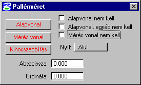
Baseline: Setting the baseline’s first and last point by pushing the DATA button. After these are set, the program asks for the final size. If the Baseline is not needed box is turne don, the baseline itself will not appear on the graph. If the Baseline and other data are not needed, the sign related to the baseline will not appear.
Measurement line: Setting the measurement ordinate lines from the graph at the end points by pressing the DATA button. If the Measurement line is not needed box is checked, the measurement line will not appear on the graph, only the signs related to it.
Extension: Setting the extension at the endpoints by pressing the DATA button.
Arrow: Above/Below. The arrow’s position relative to the baseline.
Abszcissza, ordináta: After the baseline is set, the measurement ordinate lines can also be set by setting the abszicissza and ordinates. The same apply here as in the case of the measurement line.