Web-based GIS of the Municipality of Debrecen
![]() Our most visited system. 200 daily visitors on average!
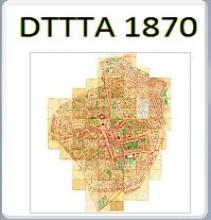
The Mayor's Office of Debrecen received the digital survey basemap in DAT exchange format and the corresponding digital aerial photo with resolution of 20 cm. Later it will be expanded with the change management of the regional development plan, too. To manage these and later on to manage and maintain the related data they needed a geographic information system, which can provide this immediately and cost-effectively. That's why they chose Erda Ltd.'s ErdaGIS system. This system is the web query version of ErdaGIS, and it is working continuously since 2008.
Our most visited system. 200 daily visitors on average!
The Mayor's Office of Debrecen received the digital survey basemap in DAT exchange format and the corresponding digital aerial photo with resolution of 20 cm. Later it will be expanded with the change management of the regional development plan, too. To manage these and later on to manage and maintain the related data they needed a geographic information system, which can provide this immediately and cost-effectively. That's why they chose Erda Ltd.'s ErdaGIS system. This system is the web query version of ErdaGIS, and it is working continuously since 2008.