
Zoning Environmental Management Plan (ZEMP) in Angkor
 in Angkor") The paper-based GIS system of archeology and monument protection was replaced by the one of the first digital solutions of the industry between 1992 and 1993.
The paper-based GIS system of archeology and monument protection was replaced by the one of the first digital solutions of the industry between 1992 and 1993.
Within the framework of a Zoning Environmental Management Plan (ZEMP) project our colleagues prepared the first MicroStation-based GIS system of the ANGKOR National Park commissioned by the UNESCO and the Royal ANGKOR Foundation. You can see some of the drawings created as a result of our work, which can be compared with the current status in GoogleMap.
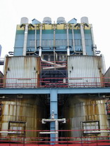 GIS system supporting the recording and ordering of surface treatment of boilers 670 t/h at Dunamenti Erômû Rt. (i.e. Dunamenti Power Station Plc.) Owing to the outdoor location of the six boilers, the corrosion protection of their steel structures imposes great challenge on the Maintenance and Quality Control Department of the power station.